
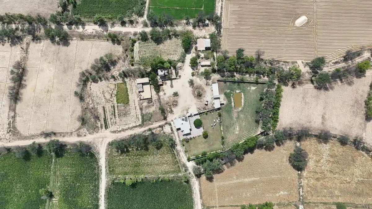
A Plus Code gives your driver an exact point to aim for when the family home has no street name, no house number and a set of directions that begin "go past the old school and ask for the chaudhry's house". In Pakistan, you create one in Google Maps by pressing and holding on the right rooftop, then tapping the short code that appears in the panel, something like the format *XXXX+XX* followed by a town name. Send that code, plus the home's nearest town, to the person arranging your journey, and ask a relative who lives there to confirm the pin sits on the actual gate, not on the neighbour's field. On the day, share a live location from the car so the family can guide the final few hundred metres by phone.
Below: how to check the pin from abroad, what to send the driver, landmark directions as a backup, and the two things that most often go wrong on the last mile to a village home, a lane too narrow for the vehicle and arriving after dark.
First, check the destination against official travel advice
Before any address work, check where the village actually is. The UK Foreign, Commonwealth & Development Office (FCDO) publishes area-by-area advice for Pakistan, and some rural home districts fall inside it. At the time of writing, the FCDO Pakistan travel advice advises against all travel to the whole of Balochistan, to a long list of districts in Khyber Pakhtunkhwa (including Peshawar, Swat, Bannu, Dera Ismail Khan, Kohat and both Dirs), to the Mansehra-Chilas section of the Karakoram Highway, and to areas within 10 miles of the Afghanistan border or the Line of Control. It advises against all but essential travel to the rest of Azad Jammu and Kashmir, Sindh north of and including Nawabshah, Dera Ghazi Khan in Punjab, within 5 miles of the India border (Wagah and the Kartarpur Corridor excepted), and the Khyber Pakhtunkhwa districts of Malakand, Mardan, Nowshera, Shangla and Swabi.
The list changes, so read the live page. If the family home is in one of those areas, a Plus Code does not change the risk picture, and travel against FCDO advice may invalidate travel insurance. This guide is about finding a house, not deciding whether a journey is wise.
Plus code Pakistan basics: what the code actually is
A Plus Code is a short address made from letters and numbers that stands for a small square on the map. Google's engineers in Zürich published the system, formally called Open Location Code, in October 2014, and it is open source under the Apache 2.0 licence, according to the Open Location Code article on Wikipedia and its cited sources. The Google Plus Codes site describes them as free to create and use, and says they work online or offline.
A few details make them practical for a village:
- No vowels. The character set uses digits 2 to 9 and letters such as C, F, G, H, J, M, P, Q, R, V, W and X. Leaving out vowels makes it unlikely a code spells a real word, and easily confused characters are left out too, so there is less to misread over a crackly phone line.
- Not case-sensitive. "8fvc+2x" and "8FVC+2X" are the same code, which helps when an older relative types it into a phone.
- Precision you can choose. A standard code with 10 characters marks a square roughly 14 metres across. Add one more character after the plus sign and the square shrinks to about 3.5 metres. For a house, 14 metres is usually enough to put the car at the right gate; for a large compound with two entrances, the longer code helps.
- Short codes with a place name. Google Maps usually shows a shortened code followed by a town, for example the Plus Codes site's own sample *97MF+27 Mumbai*. The place name fills in the missing front characters. Offline, Maps may show the full global code instead, with no town, such as the example Google gives: *9C5M8QQ7+V8*.
Why not just use the postcode?
Pakistan does have postcodes, but they do a different job. Pakistan Post introduced five-digit codes on 1 January 1988: the first two digits route mail to a district and the last three identify the delivery post office, as summarised on the Wikipedia page for postal codes in Pakistan. One post office serves many villages, so a postcode points to an area, not a door. Keep it as a cross-check only.
One limit to keep in mind: a Plus Code is a point, nothing more. It cannot tell anyone whether the lane to that point is paved, blocked by a tractor trolley, or crosses a bridge too weak for a loaded people carrier. That is why the rest of this guide pairs the code with a human check and a phone backup.
Google Maps plus code for home: creating one step by step
You can make the code from abroad, but one made on the spot is more accurate.
Option A: a relative at the house makes it
This is the best method. Ask the relative to stand at the main gate the car should stop at, not in the kitchen at the back.
- Turn on location on the phone and open Google Maps.
- Wait until the blue dot settles; outdoors, away from high walls, gives a better fix.
- Tap the blue dot, then swipe up from the bottom to find the Plus Code line.
- Tap Copy code and paste it into a message to you.
These are the steps Google gives for Android in its help page on finding and sharing a location with Plus Codes; the same page has a separate iPhone tab, so follow that if the relative uses an iPhone.
Option B: you make it from abroad
If nobody at home is comfortable with maps, you can build the code yourself from satellite view and then have it confirmed.
- Open Google Maps on your phone and switch to the satellite layer.
- Find the village by searching for its name, the nearest town, or a known landmark such as the mosque, school or a petrol pump on the main road.
- Zoom in until you can see individual rooftops and courtyards.
- Press and hold on the house to drop a pin.
- Tap the panel at the bottom; the Plus Code is listed with the location details. Tap it to copy.
Families usually recognise home from the air by something fixed: the courtyard shape, a roof tank, or where the lane meets the canal.
Checking the pin with a relative who lives there
A pin dropped from London or Dubai is a guess until someone local confirms it. Villages grow, cousins build next door, and satellite images can be years old.
- Send the code back to the house. Ask the relative to open it in Google Maps and press Directions from where they are standing. If the route says a few metres, you are on the right spot.
- Ask about the gate. Some homes have a main gate on the lane and a second door onto the fields. Confirm which one a car can reach, and move the pin if needed.
- Ask what the lane looks like now. Has it been paved, widened, or dug up for a gas or water line? Is there a new wall or a gate across it at night?
- Get a photo. A daytime picture of the gate, taken from the lane, with anything distinctive in frame: a green door, a nameplate, a tree, a shop next door.
- Confirm the nearest point a large car can turn round. This matters more than people expect, and it is covered below.
Sharing location with a driver: what to send and when
Keep it simple: one clear message the driver can open, with one person named as the contact on arrival.
The details sheet
Put the following into a single message or note, in English and, if it helps, in Urdu or the local language too:
| Item | What to write | Why it helps |
|---|---|---|
| Plus Code | The confirmed short code with town, e.g. *XXXX+XX Town*, plus the full global code | The short code for search, the long one for offline use |
| Village and tehsil | Village name, tehsil and district | Lets the driver check the general direction before setting off |
| Postcode | The five-digit code for the delivery post office | A cross-check that the pin is in the right area |
| Last landmark on the main road | Petrol pump, school, shrine, bridge, bus stop | Where the driver should phone ahead |
| Landmark directions | Three to six short lines, see below | Backup if the map misleads |
| Contact on arrival | Name and number of a relative at the house, and a second number | The person who will guide the last stretch |
| Vehicle note | Lane width, turning point, any low branches or wires | Stops a large car getting stuck |
| Gate photo | One clear daytime picture | Confirms the right house at a glance |
The illustrative codes in the table are placeholders, not real addresses.
Send it early, then again on the day
Send the details sheet when you plan the journey, so the route and vehicle can be thought through. Resend the Plus Code on the morning of travel so it sits at the top of the driver's messages.
When you plan with Pakistan Taxi, the journey planning form (planned link) is the place to put the pickup, the village destination and your notes, and the final address details are confirmed with you as the plan is worked through. We do not promise a vehicle, a fare or acceptance at the enquiry stage; that is agreed with you before anything is booked.
Live location from the car
A Plus Code guides the driver to the house. A live location lets the family watch the car come in, which is often more useful in the last kilometre.
Most families already use a messaging app with a live-location feature; one person in the car can share for the duration of the journey with the relative at home. Google Maps also has location sharing, which Google says needs a Google account, an active internet connection, and both "Use location" and Find Hub turned on for the device. Two practical points: the phone doing the sharing needs battery and signal, and signal can drop between towns. Keep a charging cable in the car and do not rely on the live dot alone.
Share the location from a passenger's phone, not the driver's. The driver should be watching the road, and it keeps your family's messages in the family's hands.
Village address directions in Pakistan: the landmark backup
A driver new to your village will trust a map, but a map cannot tell him that the turning is the one *after* the second brick kiln.
Write the directions as a short list, starting from something on the main road that nobody could miss. Each line should hold one instruction and one landmark. Here is an example format, with made-up places:
- Leave the main road at the petrol pump just after the canal bridge.
- Go straight for about two kilometres, past the government girls' school on the left.
- At the mosque with the green minaret, turn right onto the narrower lane.
- The house is the fourth gate on the left, with a black steel gate and a neem tree outside.
- Call the number below from the mosque; someone will come out to the lane.
Good landmark directions share a few habits:
- Use things that stay put. Mosques, schools, shrines, bridges, canals, kilns and petrol pumps. Avoid "the tea stall" or "where the buffalo are usually tied".
- Give rough distances. "About two kilometres" helps a driver know whether he has gone too far.
- Name the handover point. Choose one place, usually the last landmark before the lane, where the driver stops and phones. A relative walking or riding out to meet the car is the most reliable navigation there is.
- Add a second contact. One phone will be off, flat or in a pocket at a wedding. Two numbers, one of them a person who will actually be home, avoid a long wait.
Last mile to a village home: road access for larger vehicles
The motorway part of a city-to-city drive is often the easy bit. The FCDO notes that outside the major motorways the quality of roads is variable and conditions can be poor, and in remote areas surfaces can be very uneven, as set out on its Pakistan safety and security page. The last lane to a house can be narrow, unpaved, or crossed by a drainage channel.
Families with parents, children and suitcases often need a larger vehicle, exactly the kind that struggles on village lanes. Ask your relative:
- Width. Can a car pass between the walls at the narrowest point? Is there room to open the doors outside the gate?
- Turning. Where can a larger vehicle turn round: a field entrance, the school ground, the square by the mosque? If nowhere, the car may need to reverse out.
- Surface. Is the lane brick, concrete, gravel or earth? Earth lanes can turn to mud after rain.
- Overhead. Low branches, electricity wires or a roofed gateway can catch a van roof or luggage on a roof rack.
- Water. Is there a nullah, canal crossing or low spot that floods? The FCDO notes that monsoon flooding and landslides can happen, usually from late June to early October.
If the lane will not take the vehicle, plan the handover rather than hoping. The car stops at the last wide, safe spot, and family meet it there with a smaller car, a motorbike for the bags or simply extra hands. Put that meeting point on your details sheet as its own Plus Code, separate from the house, so the driver knows exactly where the drive ends.
Our guide to family luggage and intercity vehicle planning goes further into matching the number of passengers and cases to a vehicle, which is worth reading alongside the lane check.
Arriving after dark
Evening landings often mean the last mile happens in the dark. The FCDO says local driving standards are erratic, especially at night, and advises taking care on long road journeys. Village lanes are rarely lit, landmarks disappear, and the green minaret in your directions is just another shape.
If you can, plan the timing so the car reaches the village in daylight, even if that means a night in a hotel in the nearest city and an early start. Our guide to planning transport between a hotel and a family home covers how that split journey works.
If a night arrival cannot be avoided:
- Rely on the handover point. Arrange for someone to wait at the last landmark on the main road with a torch or a car with its lights on.
- Agree a call time. The passenger calls the house about 30 minutes out, then again at the handover landmark.
- Turn on the porch light. Ask the family to put a light on at the gate. It sounds obvious; it is the single best night-time landmark.
- Keep the live location running. The family can see the car and talk it in turn by turn.
When the signal drops: offline maps
Mobile coverage can thin out between towns and in some villages. Two things help.
First, Google says Plus Codes work offline. What you lose offline is the town name, so keep the full global code on your details sheet too.
Second, download the area in Google Maps before you leave the city. Google's help page on downloading offline maps explains the steps: search for the area, open its details panel, tap More, then Download offline map and Download. Driving directions work offline as long as the whole route stays inside the downloaded area, though you lose live traffic and alternative routes. Offline maps also expire and need updating, and Google notes that downloads are not available in some countries or regions, so test it at home before you rely on it.
Putting it together for a city-to-city drive
A diaspora journey to a village home has three parts: the airport, the intercity road and the last mile. Settle the Plus Code before any of them.
- At the airport, the pickup is about flight times, the arrivals hall and meeting the driver. Our guide on getting from Lahore Airport to a family home with the address right covers the city side of that handover.
- On the intercity leg, the driver needs the general direction, the town and any stops. Our city-to-city journey service is where that part is planned.
- On the last mile, the Plus Code, the landmark list, the handover point and the phone numbers do the work.
For business travellers or longer stays, our sister service iDrive, the network behind Pakistan Taxi, describes its city-to-city taxi options in Pakistan separately.
A one-page checklist
Copy this into your notes before you fly:
- [ ] Destination checked against the current FCDO advice for Pakistan
- [ ] Plus Code made at the car gate, short and full versions saved
- [ ] Pin confirmed by a relative using Directions from the gate
- [ ] Three to six landmark directions from the main road
- [ ] Handover point chosen, with its own Plus Code if the lane is tight
- [ ] Lane width, turning point, surface and overhead checks done
- [ ] Offline map downloaded on at least two phones
- [ ] Live location plan agreed, from a passenger's phone
- [ ] Arrival time planned for daylight where possible